EarthCube Building Block: CyberConnector
Bridging the Earth Observations and Earth Science Modeling for Supporting Model Validation, Verification, and Inter-comparison
What is CyberConnector
CyberConnector is a NSF-funded open source project aiming to develop an EarthCube building block for facilitating the automatic preparation and feeding of both historic and near-real time Earth Observation customized data and on-demand derived products into Earth science models.
It will automatically process the EO data into the right products in the right form needed for ESM initialization, validation, and inter-comparison. It can support many different ESMs through its standard interfaces under a unified framework.
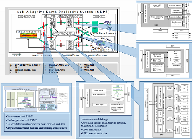
CyberConnector can also automatically serve the model outputs in interoperable forms through standard data services to facilitate rapid inter-model comparison. It bridges the sensors and earth science models through standard interfaces, such as Web Processing Service, Sensor Planning Service, and Catalogue Service for the Web.
The system is to be demonstrated with actual earth science models: the Cloud-Resolving Model (CRM), the Community Multi-scale Air Quality Model (CMAQ), and the Finite Volume Coastal Ocean Model. The final platform are to be deployed and maintained for operational ingestion, discovery, access, and present geospatial models, data, and information
Documentation
- User Oriented
- - Wiki
- - Downloads
- - COVALI
- - Search Thredds
- - VDP (Virtual Data Product)
- - Supported Process
- - FAQ
- Developer Oriented
- - Building CyberConnector from Source
- - Downloads (source code)
Domains and exemplar ESMs
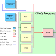
- Community Multi-scale Air Quality Model
- · open-source community-developed model for air quality simulations.
- · estimates of ozone, particulates, toxics, acid, etc.
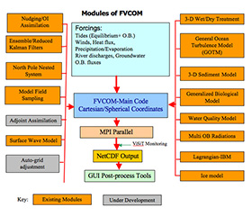
- Finite-Volume Coastal Ocean Model (FVCOM)
- · a prognostic, unstructured-grid, finite-volume, free-surface, three-dimensional primitive equation coastal ocean circulation model
- Cloud-Resolving Models (CRM)
- · simulate the response of convection and clouds to the large-scale forcing
- · resolve the cloud-scale dynamical circulations
- · improving the process-level understanding of cloud-related processes and their representation in general circulation models (GCMs)
Features
- Open Specifications
- - ISO/TC 211 standards
- - OGC specifications: CSW, WCS, WFS, WPS, SWE
- Open Architectures
- - Service-oriented architecture (SOA)
- - Representational State Transfer (REST)
- - Simple Object Access Protocol (SOAP)
- Service Composition
- - Business Process Execution Language (BPEL)
- - Business Process Model and Notation (BPMN)
- Interoperability
- - Support standard geospatial services
- - Plug-in-and-play Mode
- - Services free open access
- Reusability
- - Common service interfaces
- - Services easy to be reused
- - Service-chain-based geo-model processing