About CyberConnector
What is CyberConnector
CyberConnector is designed to extensively adopt open geospatial standards/specifications, including the ISO geospatial data and metadata standards and standard-based geospatial web service, workflows, and sensor web technologies are the foundation. It bridges the sensors and earth science models through standard interfaces, such as Web Processing Service, Sensor Planning Service, and Catalogue Service for the Web. It facilitates the automatic preparation and feeding of both historic and near-real time Earth Observation customized data and on-demand derived products into Earth science models.The standard interfaces allow the automatic handshaking between components with workflow designers and underlying workflow execution language.
This system provides users with an entrance to access the virtual geospatial data products registered in CyberConnector's CSW. The products are not present until someone requests them. Once a request is received, CyberConnector will invoke the product generation processing model on the server side and execute the model by adopting appropriate geoprocessing Web services. When the execution is over, the outputted products will be sent back to the data consumers automatically.
This work is funded by National Science Foundation (ICER 1440294 and AGS1740693).
Background
Earth observation (EO) through sensors is the most important way to collect Earth science data. It is very common that scientists who conduct data-intensive Earth science research need to integrate and analyze multi-source EO datasets, which are typically very diverse in the collecting sensors, data formats, projections, spatial/temporal resolutions and coverage, access methods, quality, documentation, and user support. Studies showed that scientists who used satellite remote sensing data for data-intensive geospatial science applications had to spend over 60% of their time just for data acquisition, preprocessing, and post-processing. The major barriers are 1) difficulty to find and obtain the needed data from geographically distributed data sources, 2) data not in ready-to-analyze form, 3) the unavailability of the needed data products, and 4) lack of or inadequate computing resources to handle the large volumes of data. The goal of CyberConnector is to remove or significantly lower these major barriers and to demonstrate the dramatic reduction of the time and efforts.
Objectives
CyberConnector aims to achieve objectives:
- Efficiently and robustly preparing and feeding EO data to ESMs
- Efficiency, scalability, and generality
- Enabling the knowledge accumulation and sharing
- Automatically presenting ESM outputs/results through the Web
- Facilitating Business Event Processing (BEP)
- Engaging in broad community participation in developing and using CyberConnector and sustaining its operation.
Framework
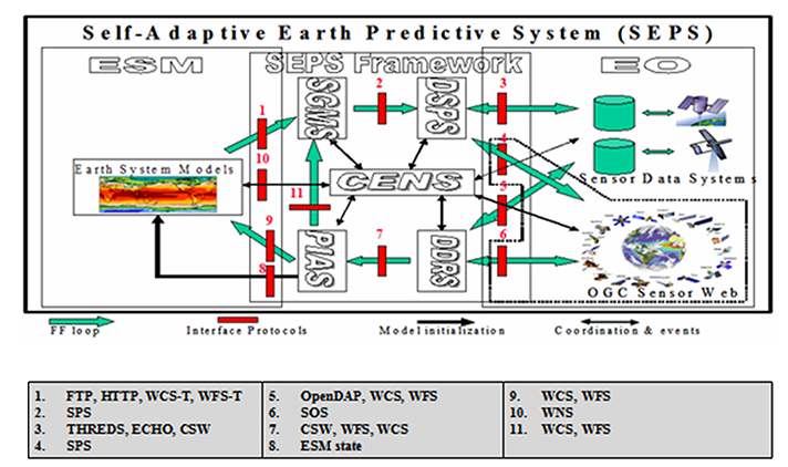
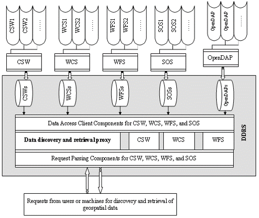
Data Discovery and Retrieval Services (DDRS)
DDRS is one of the two subcomponents in the framework that connect to the EO sensor and data world. The major functions of DDRS are to discover and obtain data. It uses open standards for interfacing with data sources, allowing a web sensor or an EO data system equipped with standard interfaces to be easily plugged into the framework.
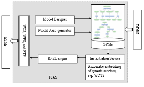
Data Preprocessing, Integration, and Assimilation Services (PIAS)
- Interactive model design
- GPM cataloguing
- BPEL execution service
- Automatic service chain through ontology and artificial intelligence
- Instantiation abstract GPMs and generation of concrete BPEL workflow
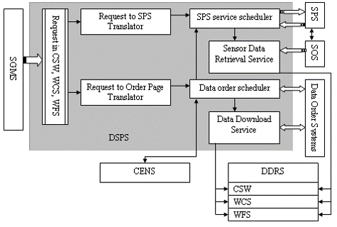
Data and Sensor Planning Services (DSPS)
- Parse the request and translate to subscriptions for SPS
- Parse the request and translate to orders for DOS (Data ordering system)
- Schedule and submit the request/order/subscription and notify CENS the creation of events
- Parse the response and retrieve the data from SOS (Sensor Observation Service), feed these data into DDRS, and notify the result to CENS
- Parse the response and retrieve data from DOS, feed these data into DDRS, and notify the result to CENS
Science Goal Monitoring Services (SGMS)
SGMS takes ESM outputs and in many cases the geophysical products generated by PIAS as inputs to analyze against science goals for determining whether additional or refined geophysical products are needed by the model to meet these goals. Use of geophysical products in SGMS rather than sensor measurements hides the complexity of the EO world from science-goal analysis and enables dynamic plug-in and removal of sensors without affecting SGMS.
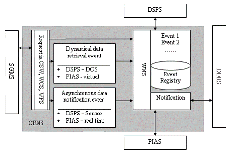
Coordination and Event Notification Services (CENS)
- Manages the messages past between PIAS, DDRS, and DSPS
- Coordinate the discovery, preparing, and downloading of data
- Notify and alert the the status of events to correpojnding services
Developers
- The developer team is Center for Spatial Information Science and Systems, George Mason University.
- The principle investigator : Prof. Liping Di (ldi@gmu.edu).
- The development leader : Dr. Ziheng Sun (zsun@gmu.edu).